A dozen volunteers gathered in Canyons of the Ancients National Monument in November to learn how archaeologists piece together the past, and why cultural sites must remain intact in order for their stories to be told.
As part of an Exploritas service project, participants came from all over the country to help the BLM survey a portion of the national monument that had never before been inventoried for archaeological resources. Exploritas is the new name for the international nonprofit program Elderhostel, which offers life-long learning and educational travel.

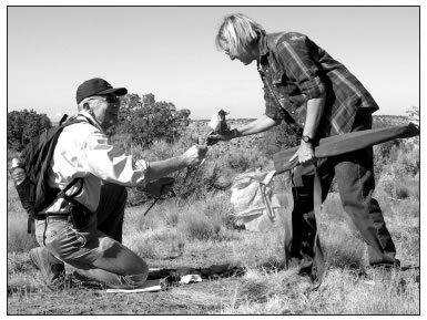
Exploritas volunteer Doug Sporn of Darnestown, Md., is handed flagging for the day from archaeologist Linda Farnsworth in preparation for conducting a cultural survey in Canyons of the Ancients National Monument. Photo by Ann Bond/San Juan Public Lands Center
Under the guidance of the BLM, McElmo Canyon Research Institute at the Kelly Place, and San Juan Mountains Association, the volunteers spent a week searching for and documenting archaeological sites on a high, dry mesa surrounding one of the monument’s Ancestral Puebloan structures.
Canyons of the Ancients, which was established in 2001 to protect cultural resources on a broad landscape scale, has the highest density of recorded archaeological sites in the nation, yet only one-quarter of its 170,000 acres has been inventoried for cultural sites.
In the past, archaeologists often focused on excavating structures and removing artifacts. Today, they concentrate their efforts on conducting surveys of surface clues spread across landscapes. The goal is to paint a picture of daily life hundreds or thousands of years ago – to learn how the native communities found food and water, and how they were able to prosper in harsh environments. Archaeologists also now consult closely with modern Native American tribes on the cultural context of what is discovered.
The key to success lies in having an intact cultural landscape to survey.
“There are certain artifacts that act like time clocks, and if someone walks away with a vital piece, we lose the evidence that can tell us important things, like what time period was involved or how the people survived,” said Jim Colleran, Exploritas coordinator for the Kelly Place.
First, the volunteers were assigned to the tasks of mapping, flagging, measuring, and recording under the tutelage of the professional archaeologists. Next, they were given the tools of the trade – clipboards and key charts, mapping tape, digital cameras, protractors, flagging, etc. – and were assigned to different areas. In addition to searching for artifacts, they were asked to identify vegetation and soil types.
“They learned there are several interrelated sciences that go into archaeology,” Colleran said.
Each carried a colorful bouquet of pin flags to mark clues they might find – ceramics, lithics or flakes, ground stone, room blocks, wall alignments, even details like rocks or plants that appeared altered or out of place.
“The composition of the colors of the flags offers a visual reference to site boundaries,” said Kristie Arrington, a retired BLM archaeologist, who coordinated the field work on behalf of the San Juan Mountains Association. “The flags can reveal different types of habitation activities, such as cooking, tool production, and trash disposal.”
As pin flags sprouted among the sand and sagebrush, patterns began to appear. One of the most exciting discoveries was a dry sloping slick-rock basin lined with large boulders. When Arrington first spied it, she suspected it had been a prehistoric reservoir. The group postulated that it also appeared to have only recently been breached. Further evidence nearby verified their theories. An old metal project tag was found tacked to the trunk of an oldgrowth juniper on the site.
“These tags were used by the Grazing Service, which later became part of the BLM, to inventory water sources, such as water traps or ponds, as suitable for livestock use between 1935 and 1950,” Arrington said. “It appears that this prehistoric reservoir was so effective that it was still holding reliable water six centuries later when the U.S. government began to regulate multiple uses in the mid 20th Century.”
Below the reservoir, the group added a series of water-control features along a major drainage to their inventory.
“These may have been used to enhance a spring and store extra runoff water,” Arrington said. “The smaller features along the terraces on either side of the drainage were check dams, which could have been used to trap soil for use in fields.”
The Exploritas group also made other discoveries that spanned centuries – from prehistoric Basketmaker habitation to a 1908 field camp important in the history of archaeology itself.
“We completed about 45 acres of intensive survey and located nine sites, including an early 20th Century camp that we believe to be the field camp of Sylvanus Morley,” Arrington said.
Morley, who worked under the auspices of both the Carnegie Institution and National Geographic Society during his career, is best known for his discoveries of Mayan structures in Meso-America. Lesser known is that Morley conducted his earliest field work in the area now within the boundaries of Canyons of the Ancients National Monument. Evidence thought to be the remains of the field camp he used during his excavation of a nearby pueblo were carefully measured, mapped, flagged, and recorded by the volunteers.
The results of the surveys will be documented in a report that will be added to the knowledge base of the monument’s cultural resources.
“The baseline information will allow us to track what kind of human and natural impacts are occurring at the sites in this area,” said Linda Farnsworth, Canyons of the Ancients archaeologist. “It will also help us determine appropriate mitigation for those impacts.”
The volunteers said they gained as much from the experience as the agency will from the information.
“I learned a new interest that I didn’t even know I had,” said Kappy Bolland of Minneapolis, Minn. “I’m fascinated with the inventiveness of these people who didn’t have the resources we do now.”
Ann Bond is a San Juan Public Lands Public Affairs Specialist


