

Dozens of potholes of this immense size and depth pepper the road east of the junction of Utah Road 262 and Indian Route 5099, otherwise marked on Google Maps as Hovenweep Road, a western access to the monument. During the past three years about 2.5 miles have been repaired with fresh blacktop at the steep decline into the canyon before Hatch’s Trading Post, where the repair ends. Road conditions there have continued to worsen, creating dangerous drives for travelers. Photo by Gail Binkly.
A transfer of ownership of some roads in San Juan County, Utah, from the county to the Navajo Nation has resulted in disappearing road signs, general confusion, and spreading potholes.
Around October 2018, Manuel Morgan, a former San Juan County commissioner, noticed that the county roads signs in his community between Ismay and Aneth were missing.
“One morning they were gone – everywhere,” he said. “No county road signs to help people find us. No one told us the county roads signs would be taken down.”
He added that he didn’t know who removed them, and, “in fact,” he said, “nobody knew who removed them, or why. How do we give people directions to our homes when there are no road signs? How do people find us when there are hundreds of miles of unpaved roads out here?”
Disappearing roads
After two years of consultations with U.S. tribes the federal Tribal Transportation Program (formerly known as the Indian Reservation Roads Program) published updated regulatory changes in 2016 addressing tribal transportation needs. Included in the final rule was the need to document rights-of-way ownership for all roads in the network of surface transportation on and around tribal land by December 2017.
The TTP, an agency of the Bureau of Indian Affairs, is authorized as part of the Federal Lands Highway Program.
According to the minutes of an April 2018 work meeting with the San Juan County, Utah, commissioners, the Navajo Division of Transportation, following the protocol required by the TTP, requested legal documentation of all rights-of-way for those routes on Navajo land in the county.
The written request was submitted by NDOT executive director Garret Silversmith, who discussed changes within the Tribal Transportation Program at the meeting, explaining that the Navajo Nation would be taking over the road maintenance program. He also informed commissioners that, effective June 1, 2018, all routes without the requested valid ROW documentation, listed as county ownership, would be changed to tribal ownership in the NDOT and National Tribal Transportation Facility inventory.
In the same meeting, then-San Juan County Commissioner Rebecca Benally confirmed that she met with Silversmith earlier in April about the transition of roads from the county to NDOT. She explained what role the county will have with road maintenance once the roads are transferred. The minutes show that the letter covering the transfer of county roads to tribal roads at that time was given to the commissioners.
In the past, the BIA Department of Transportation accepted “assumed rights-of-way.” But an updated Federal Register of the Department of the Interior requires clear documentation of rights-of-way, the April 2018 letter states. Once received the documentation would then be submitted to the National Tribal Transportation Facilities Inventory, changing the ownership from county to tribe, and forwarded to the BIA DOT and the Federal Lands Highway Program for approval.
By June the county notified NDOT that no ownership records could be found for those roads, “No documents granting Ownership of Legal ROW to San Juan County exist.”
Four months later the county notified the Navajo chapters of the changes that would occur as a result of the transfer of ownership and responsibility. The road inventory transfer was complete at that time.
Road work halts
Current County Commissioner Bruce Adams told the Four Corners Free Press that the Navajo DOT cease-and-desist order [April 2018] also ordered the county road department to take down the county road signs in the Navajo part of the county. He said that NDOT would be putting up their own. Adams was one of the three former commissioners who approved the transfer of the road inventory to NDOT.
But nearly a year earlier at the June 2017 meeting, residents of the Red Mesa Chapter, straddling the border of Utah and Arizona, were told by Commissioner Benally that the “Navajo Nation is requesting the San Juan County road department begin removing all the county road signs, as they will begin replacing them with the ‘N’ [ Navajo sign] and their own numerical system,” the minutes say.
In addition, “San Juan County road 457 will be the last main road project San Juan County will work on prior to the Navajo Nation taking over the roads. Although the San Juan County road engineer completed the road inventory, the NN has their own procedures,” she said, “and will be conducting their own inventory again.”
The San Juan County road work on Navajo roads slowly began grinding to a halt in the summer of 2017.
Tangled jurisdictions
Recognizable landscape features work very well when giving directions on the reservation to people familiar with the land. “Turn left at the second road west of Baby Rocks on the south side, then watch for the buried tire on the right. We’re the red house four miles after that down by the river.”
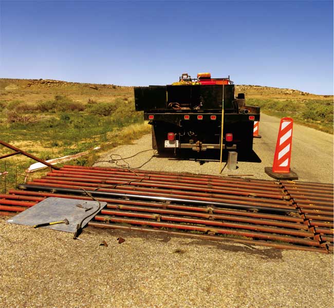
During May a BIA DOT road crew repaired the cattle guard on Tribal Road 5067, also named Belitso Road on Google Maps and also CR 401, an access road to Hovenweep from McElmo Canyon. Clearly visible in the photo, the south side sank four inches during the winter. Residents in the neighborhood placed warning signs around the cattle guard while they waited five months for a repair crew. At one point a household door braced across the south side and bound to the fence posts warned travelers with florescent tape and spray paint of the danger. Photo by Sonja Horoshko.
But for others, finding a family or location on the reservation can be intimidating and time-consuming.
Morgan has used the store at Aneth, Utah, as a pin-point, describing their home simply as a certain number of miles northwest of Aneth on CR 402. He told the Free Press in a March 2019 interview that he is not sure how to describe it as easily now. “Do we say Indian Road 5066, or so many miles from the Utah Road 162, or maybe use the BIA DOT number? How about the road names on Google, like Ismay Trading Post Road, which isn’t on a sign anywhere?” One click on any of the many road numbers on Google Maps shows a tangled web of surface transportation jurisdiction, including three and fourdigit numerical systems that designate state, county, federal BIA or tribal roads. Google also shows named roads: Ismay Trading Post Road, and South Hovenweep; roads named after local families, Belitso Road; or even some bewilderingly general names, like Reservation Road.
But most roads trickling over the land in the network of 627 road miles toward family compounds in the Navajo side of San Juan County are unnamed and also unpaved transportation arteries, difficult to maneuver in inclement weather or long winter seasons for delivery trucks or visitors.
Funding puzzles
Funding for Utah roads is collected throughout the state in a fuel excise tax. It is dispersed back to the counties for B Road (rural) and C Road (municipal) transportation infrastructure projects.
In a packet sent to chapter officials in August 2018 the county included a letter explaining that “the county approved and submitted the official San Juan County Road Map, Year 2018 to the State of Utah, Division of Transportation, updating routes and mileage claims by San Juan County to reflect the ownership changes enacted by the Navajo Nation. No further expenditures of Class B road funds is permitted under Utah State Law and regulations governing Class B & C Road Funds. As such, continued maintenance operations have ceased.”
County officials explained that San Juan County and NDOT are currently “working to establish an MOU which will lay the groundwork for future Intergovernmental Agreements and would provide the necessary funding for necessary [sic] maintenance to be performed by San Juan County. All reports of road damage or maintenance requests should be directed from the Chapter to the Navajo Division of Transportation.”
Agreements between government agencies help share the costs of surface transportation projects. In multijurisdiction circumstances, such as those affecting roads now out of the SJC ownership and into the Navajo Nation, funding from the Federal Tribal Transportation Program can be used for road maintenance and construction projects including culverts, bridges, cattle guards and road signs. The purpose of the funds is to provide safe and adequate transportation and public roads that are within or provide access to tribal land.
As of 2015, the Nation Tribal Transportation Facility Inventory consisted of approximately 47,900 miles of BIA and tribally owned public roads, 101,300 miles of state, county and local government public roads and 12,500 miles of proposed roads.
When the Free Press asked Adams if county B Road funding could follow the transferred road inventory he was adamant that no excise fuel funding will go to NDOT.
“Why would we fund the Navajo road department when all they do is sue us?” Adams asked. “We notified the Utah Division of Transportation that we no longer owned the roads and they deleted the roads from the San Juan County list of county B roads.”
Adams’ 2012 election campaign made it clear that the Navajo roads were not the responsibility of the county. At that time his campaign material held that the county should not be paying for reservation roads, that the projects are the responsibility of the BIA.
Catch-up and make-up
While transportation funding and jurisdiction issues are sorted out, the change in ownership has resulted in a weakened infrastructure on nearly all the Navajo roads in the southern half of the county.
During the past three years a lengthy section of road beginning east of the intersection of Utah State Road 262 and Indian Route 5099 has developed a mile-long strand of deep and wide potholes. About 2.3 miles of fresh blacktop repaired a section of the road last year where it begins to decline further east into the canyon toward Hatch’s Trading Post. But the project stopped west of the historic building. The blotched road still threatens the safety of travelers unfamiliar with the deteriorating conditions waiting repair by Navajo Division of Transportation, the BIA DOT, or the county.
The south side of a cattle guard has sunk four inches from the surface of the road during the past winter about five miles past Hatch’s on the same road but closer to Hovenweep where it intersects with Tribal Road 5067, also labeled Belitso Road.
During the four months that the cattle guard was broken, neighborhood residents marked the perilous site with fluorescent tapes and cardboard spray-painted signs, and even a household door at one point, warning drivers of the danger. Finally, a road crew from the BIA office in Shiprock responded to a request from the Aneth Chapter officials in May 2019 and repaired the hazard.
Herby Larsen, a transportation manager for BIA DOT Gallup regional offices explained that they replaced the original hollow metal tubes with a structural solution that can withstand the heavy trucks and traffic count on the road. According to the NDOT Priority 2019 maps, 250 – 500 vehicles use the road per day. That same road is described in the priorities list as having an unclassified status for level of maintenance, roadbed and shoulder conditions.
The cost, said Larsen, was about $26,000.
With materials and work crews in short supply it is difficult for them to repair all the potholes, even on the same road, Larsen explained. They simply don’t have the budget. Larsen explained that priorities are the only way to manage the work load and NDOT, whom the BIA DOT works with on Navajoowned roads projects, “has asked each chapter on the Navajo reservation to prioritize 15 miles of road for maintenance and repair.”
There are 110 chapters in 27,413 square-miles of the Navajo Nation, and a population of roughly 350,000 people. Fifteen miles of road per chapter is barely enough to keep up with the deteriorating conditions.
The chapters must now follow procedures to report county road damage to NDOT instead of the county road department. Morgan suggests that chapters still apply for Utah B Road funding for the local projects. “Native people are residents of this county and state and pay those fuel excise taxes just as everyone else does who uses the roads in our county.”
Improving relationships
Near Monument Valley, Oljeto Chapter President James Adakai says that there was a breakdown in communications over the road transfers. Chapters were not informed until August 2018, when they received the packet of information about the new procedures. By that time the transfer was already done and as the jurisdiction funding is sorting out, the road conditions continue to worsen.
“The letters informed us about the road inventory transfer and what the next steps will be for the maintenance of roads in the county. But the chapters were not notified that this transfer was taking place. There was no transparency with tribal and county officials at all about this issue. Normally we inform our chapter members at monthly meetings, giving them a chance to weigh in on the decisions. This was a little different. It felt political. At the time the transfer was taking place, our county commissioner, Bruce Adams, stopped coming to meetings.”
Adakai says that the people are confident things will improve with the new county commissioners representing them now.
“The three prior years saw our chapter relationship with the county greatly hurt by politics. In the past we may have had differences, but we all know we have the same constituents and can’t limit services to our people. We’ve had a good working relationship with the county at times and other counties in Arizona and New Mexico have good agreements with their Navajo chapters for these types of road issues. They work together on roads. I think we can too.”
Addenda
At press time, Morgan telephoned the Free Press to report that a couple new road signs were going up near his home. One says, La Rancho Road and another says N5068. His home does not have a new sign or address yet, but according to the new signposts, Belitso Road was renamed Cahone Mesa Road, he said.